
Welcome to the Santa Barbara County Breeding Bird Study (BBS). Through a collaboration with UCSB’s Cheadle Center for Biodiversity and Ecological Restoration (CCBER), Santa Barbara Audubon Society’s BBS development team has found an exciting solution for mapping and enabling access to the data using ArcGIS software.
The new BBS Web Map provides an interactive interface for exploring the location, timing, and other key details of breeding activity of 183 bird species that currently breed or have bred in Santa Barbara County, including four of the Channel Islands. The data can be viewed, filtered, and queried by using a set of pre-determined filters, a spatial selection tool, and/or creating your own filter. A significant feature of the BBS Web Map is that photographs accompany many of the records thereby providing key visual evidence of an individual bird’s breeding activity.
by Adrian O'Loghlen
Devereux Campus 09 July 2020

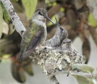
by Adrian O'Loghlen
Quiota Creek 10 July 2020
As of October 2024, more than 12,866 observations of 194 species in the county including 4 offshore islands. More than 409 citizens and scientists have contributed recent and historical records. Birders’ observations, contract studies, theses dissertations, records extracted from bird cams, scientific literature, and museum records are the sources of the data. Bringing these data together allows explorations that can inform conservation, bird watching, research, environmental planning, land management, and education at several levels.
The detailed breeding data in the BBS complements the data available in Paul Lehman’s study of bird status and distribution, “The Birds of Santa Barbara County, California”. First published in 1994 through The Vertebrate Museum (now CCBER), and updated annually, this essential reference to the status and distribution of all bird species detected in the county is available for download at no cost HERE. The BBS Web Map shows Paul Lehman’s ornithological districts of Santa Barbara County directly on BBS generated maps.
Submit your observation:
Nesting is only one stage in the process of raising a bird to independence. We want your observations not only of nesting, but of nest construction, copulation, birds on nests, food carries by adults, begging fledglings, and dependent young birds. You will see the diverse evidence that can be used to document breeding as you dig into the BBS Web Map.
Submission is simple and best done at home. If you have a photo as part of your evidence, prepare that first. Please reduce the photo size to 1MB or less. Then, open the Observation Submission Site. The breeding observation submission tool finds coordinates once you place your observation on the map.
Mark Holmgren and Adrian O’Loghlen will receive your records and, within a few weeks, upload them into the BBS web map. Any changes or updates to the submission should be emailed to Mark at email hidden; JavaScript is required.
Explore the Data:
Open the BBS Web Map HERE:
Mark Holmgren has prepared three short videos to show how the BBS data consisting of 12,000 observations of 183 breeding species on the Web Map can respond to your questions.
Links to the Videos:
We hope you find that the Santa Barbara County Breeding Bird Study is an easy to use, informative, and helpful resource.
Mark Holmgren and Adrian O’Loghlen
